Abstract
The role of the Arctic Ocean in the global climate system during the last climatic cycles remains conjectural, but radiocarbon-based chronologies and proxy data provide reliable information about the present interglacial. In the western Arctic, paleoceanographic data demonstrate a linkage between increasing Pacific water fluxes, resulting from the postglacial submergence of the Bering Strait, and the progressive warming, until climate conditions stabilized when sea level reached its present-day limit during the late Holocene. Meanwhile, the southeastern Arctic Ocean evolved from optimal conditions toward a perennial sea ice cover with cooling. We hypothesize that sea level, which determines the depth of Bering Strait and the submergence of the Arctic shelves, has led to enhanced production of seasonal sea ice and an increased freshwater export to the North Atlantic Ocean, since the onset of the present interglacial until preindustrial time.
INTRODUCTION
Predicting the future of the Arctic Ocean in response to the ongoing climate change is still a matter of debate (1). The fate of the sea ice cover that plays a direct role in the energy budget at the Earth’s surface, due to the albedo feedback (2) and the hydrography of the Arctic Ocean deserves special attention. Not only does the freshwater budget of the Arctic Ocean drive the salinity and stratification of its upper water mass, in turn playing a role in freezing conditions and sea ice formation (3), but the export of freshwater from the Arctic Ocean to the North Atlantic Ocean impacts the Atlantic Meridional Overturning Circulation, thus the world ocean circulation (4). From this point of view, the Bering Strait, which is the only connection between the North Pacific Ocean and the Arctic-North Atlantic oceans and thus controls water fluxes from the Pacific to the Arctic Ocean, acts as a critical gateway in the climate-ocean system. Because the salinity of the Pacific upper water mass is relatively low compared to that of the Atlantic water, Pacific water fluxes through the Bering Strait may weigh importantly on the freshwater budget and sea ice extent of the Arctic Ocean and potentially on the surface and deep ocean circulation in the North Atlantic (5).
Although relatively shallow (~50 m), the Bering Strait allows presently a northward flow of up to 1.2 sverdrup (Sv = 106 m3 s−1) from the Pacific Ocean to the Arctic basins, where it is a net source of heat and freshwater (6, 7). At a regional scale, in the Chukchi and Beaufort seas, this flow of low saline and relatively warm and nutrient (e.g., Si)–rich water determines the thermal properties in the upper water layer and supports high primary productivity [e.g., (7–9)]. The Pacific Ocean flux to the Arctic Ocean also represents a substantial part of the total freshwater input to the Arctic, which averages about 75% in the Canadian basin (10) and about 30% at the scale of the whole Arctic Ocean (11, 12). As the Pacific water is ultimately exported to the subarctic North Atlantic, it may affect the deep water formation, overturning circulation, and thus the world climate (4, 13, 14). Hence, any change in Pacific water fluxes through the Bering Strait may have significant regional as well as global impacts on the ocean climate system, on both short (interannual) and long (decadal to centennial) timescales.
Changes in the flux of Pacific water through the Bering Strait occur not only at short timescales due to internal climate mechanisms but also at longer timescales in response to geological forcings. At the scale of the last decades, satellite data and direct observations indicate variations ranging from 0.7 to 1.2 Sv, in relationship to wind-driven ocean circulation (15). At the scale of the last glacial to the present interglacial interval, they varied from 0 up to present-day values. The transition was gradual from a land bridge with a closed Bering Strait that enabled human migration to an ocean connection, which was first established about 11,000 years ago (16) and progressively deepened afterward, up to the modern situation. Hence, the recent geological archives provide the opportunity to explore the impact of increasing fluxes from the Pacific to the Arctic Ocean on both regional and hemispheric scales.
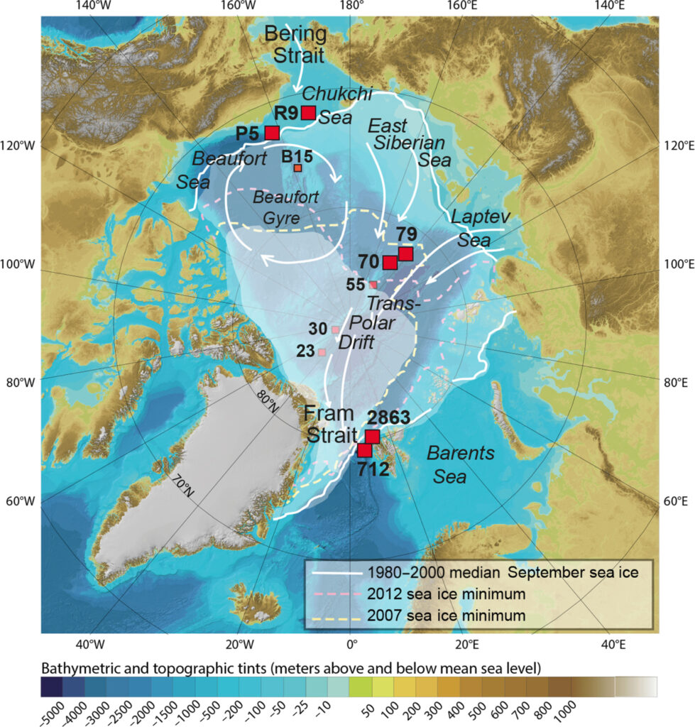
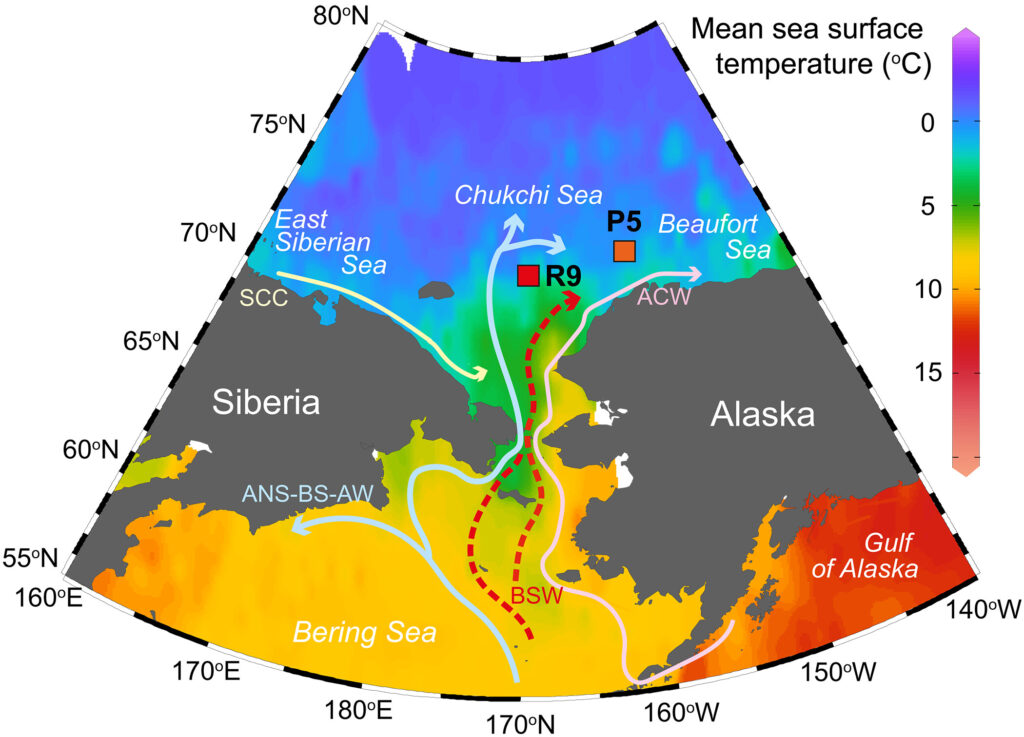
Using published and new sediment core data (Fig. 1 and Table 1), we examine here the oceanographical changes in the Arctic Ocean during the present interglacial with special attention paid to the Chukchi Sea area (Fig. 2), where the flooding of the Bering Strait and postglacial sea level rise led to increasing Pacific water inflows (17). We also compare paleoceanographic records from the Pacific to the central and Atlantic sectors of the Arctic Ocean (18, 19), which provide strong evidence for contrasted west-east trends in the Arctic Ocean climate over centennial to millennial timescales.
| Core name | Short name | Latitude | Longitude | Water depth (m) | References |
|---|---|---|---|---|---|
| PI-92-AR-BC15 | B15 | 75.73 N | 160.86 W | 2035 | (22) |
| ARC4-R9 | R9 | 71.96 N | 168.94 W | 51 | This study |
| HLY0501-05JPC | P5 | 72.69 N | 157.52 W | 415 | (24) |
| PS2863-1 | 2863 | 80.56 N | 10.29 E | 808 | (19) |
| MSM5/5-712-1 | 712 | 78.916 N | 6.934 E | 1490 | (19) |
| PS87/023-2 | 23 | 86.631 N | 44.874 W | 2439 | (18) |
| PS87/030-3 | 30 | 88.61 N | 61.43 W | 1277 | (18) |
| PS87/055-1 | 55 | 85.69 N | 148.82 E | 731 | (18) |
| PS87/070-3 | 70 | 83.8 N | 146.12 E | 2000 | (18) |
| PS87/079-3 | 79 | 83.2 N | 141.38 E | 1358 | (18) |
Table 1. List of cores referred to in the text, with references for the dinocyst data.
The data from the core name in bold characters were used for the triptych of Fig. 5.
RESULTS
Palynological data from the Chukchi Sea (Western Arctic) core ARC4-R9
The approach used to document sea surface conditions relies principally on the comparative study of the palynological contents of sediment cores collected in the Chukchi Sea, the central Arctic Ocean, and the Arctic-North Atlantic gateway. More specifically, we used the assemblages of organic-walled cysts of dinoflagellates (hereafter dinocysts) that provide information on primary productivity and sea surface conditions, including the seasonal extent of the sea ice cover, salinity, temperature, and productivity (20, 21). The advantage of using dinocyst proxies in a subarctic context relies on their good preservation and a relatively high species diversity, in addition to exhaustive documentation about the distribution of their modern assemblages (21), allowing the use of transfer functions and analog approaches for quantitative reconstructions of past conditions in surface waters of high latitude marine environments [e.g., (22, 23)].
Some dinocyst-based records from the western Arctic Ocean are already available. They illustrate the spatial and temporal variations in sea surface conditions during the Holocene (22, 24–26). Here, we add a new record from core ARC4-R9 (R9 in Figs. 1 and 2; 168°56.40′W, 71°57.80′N; water depth of 51 m; chronology provided in table S1 and fig. S1), which is located in the northward-flowing pathway of major components of the Bering Strait Water originating from the Bering Sea and the northern Pacific (Fig. 2). The isotope composition of the exchangeable fraction of neodymium (Nd) in sediment was also used as an independent indicator of Pacific water fluxes toward the Arctic Ocean (see Fig. 3, table S2, and fig. S2) (17).

The palynological content of this core is extremely rich and diversified with abundant (thousands per gram) dinocysts, pollen grains, and spores, as well as organic lining of benthic foraminifers, in addition to common (hundreds per gram) cysts and loricas of ciliates, chlorophytes algae, etc. (see Fig. 3 and table S1). The dinocyst abundance is up to 13,000 cysts/g leading to estimated fluxes of around 200 cysts cm−2 year−1. Such fluxes illustrate a very high productivity, as also demonstrated by a high content in organic linings of benthic foraminifers. The dinocyst assemblages include both phototrophic and heterotrophic taxa (Fig. 3 and table S2). Among phototrophic taxa, Operculodinium centrocarpum, the cysts of Pentapharsodinium dalei and Spiniferites elongatus dominate. They are accompanied by some occurrences of Impagidinium pallidum and Spiniferites ramosus. The heterotrophic taxa are dominated by Islandinium minutum and Brigantedinium spp., accompanied by Selenopemphix quanta, Polykrikos type Arctic, and many other species occurring in low numbers. The overall assemblage is typical of subarctic environments (21, 23, 27, 28). One particularity of the record, however, is the occurrence of Polykrikos schwartzii, Selenopemphix nephroides, and Quinquecuspis concreta. These species were reported to occur in surface sediments of high latitudes in the North Pacific but not in the subarctic North Atlantic [e.g., (21, 27, 28)]. We see here an indication of species dispersal by Pacific waters entering the Arctic through the Bering Strait.
Chukchi Sea (Western Arctic) changes in sea surface conditions
The reconstruction of sea surface conditions (Fig. 4) indicates a variable but generally dense sea ice cover, fluctuating mostly between 50 and 75% of the mean annual concentration. This corresponds to variations from about 6 to 9 months/year and appears close to slightly lower than modern values [73.0 ± 15.7%; 1950–2011 data from the National Snow and Ice Data Center in Boulder; (29)].
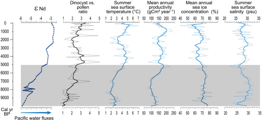
The reconstruction also shows a low and variable summer salinity ranging from 24.0 to 32.5 practical salinity unit (psu), which encompasses the modern values [29.4 ± 2.0 psu; 1955–2017 data from the World Ocean Atlas; (30)] but is lower than the salinity of Pacific waters flowing through the Bering Strait [~31.9 to 33 psu; (6, 31)]. This points to the high dilution of oceanic waters with freshwater related to the seasonal melting of sea ice, precipitations, and fluvial discharges, in addition to the inflow of Pacific water of low salinity relative to Atlantic waters. Fluvial discharge occurred throughout the sequence, reaching a maximum before ~8000 cal years B.P. (calibrated years before the present), as illustrated by Pediastrum concentrations of the order of 103 colonies/g of dry sediment (Fig. 3). High inputs of terrestrial organic matter at the base of the record, which then decrease upward, are also shown by the high proportion of terrestrial palynomorphs (see dinocyst/pollen ratio in Fig. 4) and by the isotopic composition of organic carbon (fig. S3). Such a trend of decreasing organic carbon from terrestrial origin from the early to late Holocene was observed in the nearby core HLY05-01-05JPC (24). The decrease in terrestrial inputs could be attributed to the more distal offshore location of the core site with higher sea levels but cannot be used to assess salinity changes.
Although micropaleontological data provide information on salinity and the origin of organic fluxes, they cannot serve to weigh the respective contributions of the freshwater sources in the regional context of the Chukchi Sea. Nevertheless, the Nd values permit deciphering the relative importance of the Pacific source in the fluxes of fine particulate matter (Fig. 4) (17). From this viewpoint, the trend of −6 to −3 in εNd values of the exchangeable Nd marks the increasing inflow of Pacific waters entering the Arctic Ocean (17), with a salinity of ~32 to 33 psu (6, 31), before further dilution.
The estimated sea surface temperature (SST) ranges from 1° to 7°C in summer. Cold conditions (<3°C) characterized the early part of the record, and a distinct warming trend from ~2° to ~5°C is recorded during the middle Holocene, from ~8000 to ~4500 cal years B.P. During the late Holocene, a cold phase marked the 2500 to 1500 cal years B.P. interval and a later optimum that occurred around 500 cal years B.P. Such SST variations are atypical for the Holocene (32, 33) but show regional consistency with other records from the Chukchi Sea in the western Arctic Ocean (for example, sites B15 and P5 of Fig. 1) (22, 24, 25). Last, the primary productivity estimated from dinocyst assemblages in core ARC4-R9 suggests an increase after ~6500 cal years B.P. In the context of the western Arctic Ocean, both the warming trend and the productivity increase of the middle Holocene may have resulted from the enhanced inflow of the relatively warm and nutrient-rich Pacific water (17).
Contrasts between the Pacific, central, and southeastern Arctic Ocean areas
The changes in sea surface conditions of the western Arctic Ocean (Figs. 4 and 5) are regionally consistent but differ from conditions in other parts of the Arctic Ocean and subarctic seas. A progressive warming in surface water accompanied the increasing Pacific water flux during the middle Holocene until the sea level reached its present-day level after 3000 years B.P. (34). This contrasts with records from the southeastern Lomonosov Ridge that show seasonally sea ice–free conditions, at least episodically during the early and middle Holocene, and the development of a perennial sea ice cover, thus a cooling, during the late Holocene (18). A trend toward harsher conditions and denser sea ice in the late Holocene has been documented for the East Siberian Sea and the Laptev Sea based on microfaunal and biomarker studies [e.g., (35, 36)]. In the eastern Fram Strait, along the incoming northward route of the North Atlantic Water, a cooling in surface waters is also consistently recorded from the early to late Holocene, not only based on dinocyst assemblages [e.g., (19); Fig. 5] but also based on other proxies, such as foraminifera and biomarkers [e.g., (37)]. This cooling trend throughout the middle and late Holocene up to preindustrial time is similarly recorded at many locations of the northern North Atlantic (32, 33). It is commonly attributed to the decreasing summer insolation. However, at the scale of this northern sector of the North Atlantic Ocean, a strong regionalism in the trends of SST points to the importance of the large-scale ocean circulation in the redistribution of heat (38).

Sea level change as a critical forcing in Arctic sea ice cover
Several studies document the paleoceanographic changes in the Bering Strait area since the last glacial maximum from the initial opening of the Strait (16) through its deepening until about 3000 to 2500 years ago when the sea level stabilized close to its modern limit (34). The regional history of sea level changes is well-documented by sedimentary records from the Chukchi Sea that show very high sediment accumulation rates with abundant terrigenous inputs until about 8000 years B.P. [e.g., (24)] and then by paleo-marsh records from northern Alaska that show a final 1.5-m sea level rise over the past 6000 years (39). The sea level rise and deepening of the Bering Strait necessarily resulted in increased fluxes from the Northern Pacific toward the Arctic Ocean. In the Chukchi Sea, they resulted in the warming of surface water, in particular during the late Holocene, as shown by geochemical and palynological data of core ARC4-R9 presented above (Fig. 4).
Beyond the impact on regional SST, the increasing flux of Pacific water likely played a role in the Arctic sea ice regime as it may contribute both to the strengthening of the Beaufort Gyre and an overall lowering of the salinity in the upper water masses in the Arctic Ocean (5). Furthermore, sea level rise affected the East Siberian Sea and Laptev Sea shelves, which are wide and shallow. The flooding of these shelves occurred mostly during the early Holocene, with close to present-day coastlines and modern-like hydrography being reached 6000 to 4000 years ago [e.g., (40–42)]. The submergence of the Arctic Ocean shelves led to the development of “ice factories” over wide areas characterized by shallow and well-stratified water masses, where most of the yearly sea ice production took place (29). Hence, the submergence of the Arctic Ocean shelves during the early Holocene increased the net Arctic sea ice production rate (18). This is one of the mechanisms that may explain the denser and thicker sea ice cover of the central to southeastern Arctic Ocean, which is illustrated by the near-total collapse of productivity (Fig. 5B) and the lower temperatures (Fig. 5C) during the late Holocene (18, 19) [cf. also (35–37)].
While the Bering Strait, the Chukchi, East Siberian, and Laptev shelves were increasingly flooded throughout the early Holocene, the Barents Sea was marked by decreasing relative sea levels due to postglacial uplift (43). Hence, the Atlantic Water flow into the Arctic Ocean through the Barents Sea Opening was likely higher during the early Holocene than during the late Holocene. Accordingly, an enhanced inflow of this relatively warm Atlantic Water through Fram Strait and along the eastern Arctic margin followed, notably in the southeastern Lomonosov Ridge area (18).
DISCUSSION
The integration of the Arctic Ocean into the global climate system implies interactions with lower latitudes through atmospheric circulation and oceanic water mass circulation. From this point of view, the gateways to the Arctic are determinant, and the shallow Bering Strait linking the Pacific and Arctic deserves special attention as it experienced on-and-off connections during the Quaternary forced by sea level changes. Under the high sea level of full interglacial conditions, poleward heat transfer and freshwater fluxes through the Bering Strait affect sea ice and freshwater budget over the Arctic Ocean, with potential consequences on the salinity of the northern North Atlantic and the Atlantic Meridional Overturning Circulation (14, 44). In addition, sea level determines the status of the Arctic shelves, submerged during interglacials, and exposed during glacials, thus playing a determinant role in the rate of sea ice production. During the early Holocene, the low sea level in the Bering Strait and East Siberian-Laptev Seas areas restricted the inflow of Pacific waters to the Arctic and contributed to low sea ice production on the shelves. Conversely, in the Fram Strait and Barents Sea areas, high sea levels were recorded during the interval due to the residual isostatic depression of the Fennoscandian ice sheets, leading to high Atlantic water fluxes into the Arctic Ocean, especially along the continental margins of the eastern Arctic shelves (43). Hence, on the basis of our results and taking into consideration the overall evidence available, we hypothesize that sea level is a parameter that would account for at least part of the opposite behavior of the eastern versus western Arctic Ocean, regarding SSTs and the sea ice cover, throughout the present interglacial. We may further propose that the submergence of Russian Arctic shelves that fostered enhanced Arctic sea ice formation and areal extent of Arctic sea ice weighted significantly in the cooling trend of the mid to late Holocene of the area (32, 33, 45). This seems coherent with the fact that the largest amplitude cooling from early to late Holocene is recorded in the western North Atlantic, on the route of the Arctic water outflow toward the North Atlantic and the world Ocean (38).
In the context of long-term global warming and sea level rise, exchanges through the Bering Strait deserve special attention as enhanced fluxes of Pacific water into the Arctic may be expected and could further contribute to regional warming and sea ice decline (46, 47). Furthermore, an increased inflow of the Pacific water could modify the freshwater budget of the Arctic Ocean, with possible consequences on the freshwater export to the northern North Atlantic as well as on the ocean stratification and deep water formation, thus on the Atlantic Meridional Overturning circulation, as documented by Shimada et al. (46). Data and modeling experiments point to the potential role of the fluxes at Bering Strait on the Arctic freshwater budgetand the instability of the North Atlantic Ocean at multidecadal timescales (48, 49) as well as on major climate changes at geological scales (50).
The sea level rise close to 1 m expected by the end of the 21st century (51) is of the same order of magnitude as that recorded over the last four millennia (34). A 1-m amplitude of sea level rise in the Bering Strait, which lies about 85 km wide, may seem modest but will enhance the Pacific water flux into the Arctic Ocean. Song et al. (17) proposed quantitative relationships between the εNd composition of water in core ARC4-R9, sea level, and the Pacific water flux through Bering Strait. On the basis of their algorithms, a +1-m rise in sea level would result in a Pacific water flux increase of ~0.055 Sv. Such an estimate is approximative, and a more realistic value would require information about all other parameters governing water circulation through the Bering Strait. Nevertheless, even small changes in the northward flow of Pacific water through the Bering Strait may have an impact, not only on regional sea ice and Arctic warming (47) but also on the Arctic freshwater budget and the Arctic-Atlantic hydrography (48, 49). Although the effective weight of enhanced Pacific fluxes to the Arctic and Atlantic Oceans climatology relative to other processes needs to be more accurately determined and weighted, this paper shows that recent geological archives offer the opportunity to assess the impact of a deepening of the Pacific-Arctic gateway.
MATERIALS AND METHODS
Part of the data used in this study was published (Table 1). The 14C dates and the εNd data of core ARC4-R9 are reported in (17). The dates and the ages versus depth model with uncertainties are presented in table S1 and fig. S1. The propagation of the uncertainty on the εNd data (table S2) is illustrated in fig. S2.
The age-depth relationship in cores ARC4-R9 from the Chukchi Sea (this study; fig. S1) and PS2863 and MSM5/5-712 from the Fram Strait (19) were established after calibration of 14C dates on biogenic carbonates using the Marine13 calibration curve (52) with the Bacon package (53). Corrections (delta R) were applied for each study site to account for the potential ocean reservoir effect at regional scales. The chronology in the cores PS87/70-3 and PS87/79-3 from the Lomonosov Ridge (18) were also established after calibration of the 14C dates using the Marine13 calibration curve (52).
The palynological data from core ARC4-R9 collected in the Chukchi Sea, including the concentrations of palynomorphs and the percentages of dinocyst taxa, are reported in tables S3 and S4. All data were produced using the standardized procedures of the marine palynology laboratory of Geotop at the Université du Québec à Montréal (UQAM) [see (21)]. Briefly, the samples were wet-sieved at 10 and 106 μm to remove fine silts and coarse sand particles. The remaining 10- to 106-μm fraction was treated with hydrochloric acid (10%) and hydrofluoric acid (52%) to dissolve carbonate and silica. Oxidation treatments were avoided as some dinocyst taxa could be altered. The marker-grain method by introducing spores of Lycopodium clavatum in tablets was used to calculate concentrations.
The palynological content of the sediment provides information on the source of organic fluxes, marine or terrestrial, based on the dinocyst versus pollen ratio in core ARC4-R9 (see Fig. 4). An independent indication of the source of organic fluxes comes from the isotopic composition of organic carbon (see fig. S3 and table S5), which shows a trend identical to the one reported from nearby core HLY0501-05JPC (24).
The estimation of the sea surface conditions in core ARC4-R9 was made using the modern analog technique (54) applied to the n = 1968 dinocyst database (21), which includes 704 data points north of the Arctic Circle and thus appears appropriate for the reconstruction of surface ocean condition in Arctic and subarctic settings. The best estimates were calculated from a set of five analogs after the logarithmic transformation of occurrences to emphasize the weight of accompanying taxa (25). The most probable values are given by the average of environmental data at the five selected analog sites weighted inversely to the distance (54). The reliability or uncertainty of the reconstruction can be evaluated through several means. As for most transfer functions based on assemblages, the general accuracy of the approach is evaluated from the coefficient of correlation (r2) between reconstructions and observation in the modern database and the root mean square error (RMSE), which is the standard deviation (SD) of the difference between observation and reconstructions. In the case of the n = 1968 dinocyst database that covers a large domain from the equator to the pole, the r2 and RMSE are, respectively, 0.962 and ±1.7°C for summer temperature, 0.736 and ±2.0 psu for summer salinity, 0.857 and ±12% for sea ice cover concentration, and 0.874 ± 95 gCm−2 year−1 for mean annual productivity. Such RMSEs are close to the SDs of modern values as measured at the study site ARC4-R9 [±1.97°C and ±2.0 psu for summer SST and salinity from 1950 to 2017 in the World Ocean Atlas 2018; ±15.67% for mean annual sea ice concentration from 1955 to 2017 archived at the Snow and Ice Data Center in Boulder (29)] and in the overall reference database [e.g., (55)]. When making calibration from regional subsets of data, the RMSE can be narrowed (56), but using a reduced dataset requires the assumption that all past conditions to be reconstructed are included in the regional dataset. We preferred to avoid such an assumption and used the entire hemispheric database [n = 1968; (21)]. With the analog technique, the reliability of the approach and the range of uncertainties are further given from the similarity of the modern analogs and the ranges of environmental values they encompass (see fig. S3 and table S5). Here, the high dinocyst concentrations and counts (~200 specimens per sample on average) and the similarity of the modern analogs, well below the adopted threshold, point to the robustness of the results. The reconstructions of SSTs from dinocyst data in cores HLY0501-05JPC, PS2863-1, and MSM5/5-712-1 presented in Fig. 5 were updated using the n = 1968 database (21) for consistency (see tables S6 and S7).
Nd isotope changes through the Holocene revealed quantitatively related to the flux of northern North Pacific source water (17). The impact of a potential 1-m rise of sea level over Bering Strait on this flux has thus been tentatively estimated extrapolating the relationship between sea level and Nd in core ARC4-R9 [see fig. S5, table S10, and (17)]. Leachates of surface sediments from the northern Bering Sea shelf yielded an εNd value of ~−2.0 ± 0.6 [1σ; n = 4; (57)]. This value is considered representative of the Nd isotope composition of the North Pacific water mass at its entry of the Bering Strait (57). We further assume that Pacific water flux was negligible during the early Holocene and that it rose to its present average of 1 Sv [mean modern value; (6, 7)] mostly over the past 8000 years. We also consider that the flux of Pacific water has been proportional to the shift in εNd values from about −6, at ~8000 years B.P., to approximately −2.7, at present. The resulting relationship (see fig. S5) leads to extrapolating a flux increase of about 0.055 Sv for a +1 m further rise in sea level. This estimate is to be seen with caution. First, because the εNd–Pacific water flux extrapolation follows the near-asymptotic trend of the curve illustrating the εNd–Pacific water flux relationship since 8000 years B.P., aside from the fact that a proper estimate of changes in the Pacific water flux under a rising high global SL would require information about all parameters governing water circulation through Bering Strait in addition to estimating the deepening and enlargement of the strait itself. A more realistic estimate would also require information about subsequent changes in the seasonal duration of the sea ice cover and the wind regime.
Acknowledgments
Funding: This work was supported by Natural Sciences and Engineering Research Council (NSERC) Canada Discovery Grants to A.d.V. and C.H.-M., Fonds de Recherche du Québec Nature et Technologies (FQRNT) supports to the Geotop research network (A.d.V., C.H.-M., T.S., T.R., and J.F.) and through scholarships (J.F.), National Natural Science Foundation of China (42176245), and the Fund of Laoshan Laboratory (LSKJ202204200).
Author contributions: Conceptualization: A.d.V. and C.H.-M. Methodology: A.d.V., C.H.-M., T.S., T.R., and J.F. Investigation: A.d.V., C.H.-M., T.S., Y.L., T.R., and J.F. Visualization: A.d.V., C.H.-M., and T.S. Funding acquisition: A.d.V., C.H.-M., and Y.L. Supervision: A.d.V. and C.H.-M. Writing—original draft: A.d.V. and C.H.-M. Writing—review and editing: A.d.V., C.H.-M., T.S., Y.L., T.R., and J.F.
Competing interests: The authors declare that they have no competing interests.
Data and materials availability: All data needed to evaluate the conclusions in the paper are present in the paper and/or the Supplementary Materials.

Average Rating